

RealEarth

คำอธิบายของRealEarth
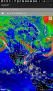
The RealEarth app provides access to real-time imagery and data products hosted by the University of Wisconsin - Madison Space Science and Engineering Center (SSEC). These products include global and regional remotely sensed atmospheric, terrestrial, and oceanographic imagery, observations of local meteorological parameters, and short-range predictions of future conditions. Features include:
- Select products to display by category, name, and time
- Pan and zoom map interface dynamically
- Display current location on map
- Animate by relative or absolute time steps
- Save custom favorites
Future enhancements will include capabilities for users to create custom geographic areas that will denote notification regions. Events such as severe weather, floods and fires will trigger a notification message directly to the user's mobile device.
แอปพลิเค RealEarth ให้การเข้าถึงแบบ real-time ภาพและข้อมูลผลิตภัณฑ์ที่จัดทำโดยมหาวิทยาลัยวิสคอนซิน - เมดิสันอวกาศวิทยาศาสตร์และศูนย์วิศวกรรม (SSEC) ผลิตภัณฑ์เหล่านี้รวมระดับโลกและภูมิภาคลิ่วรู้สึกบรรยากาศบกและภาพผู้ประสานงานการสังเกตของพารามิเตอร์อุตุนิยมวิทยาท้องถิ่นและการคาดการณ์ระยะสั้นของเงื่อนไขในอนาคต รวมถึง:
- เลือกผลิตภัณฑ์ที่จะแสดงตามหมวดหมู่ชื่อและเวลา
- อินเตอร์เฟซการแพนและซูมแผนที่แบบไดนามิก
- แสดงตำแหน่งปัจจุบันบนแผนที่
- การเคลื่อนไหวโดยขั้นตอนเวลาญาติหรือแน่นอน
- บันทึกรายการโปรดที่กำหนดเอง
การปรับปรุงในอนาคตจะรวมถึงความสามารถในการให้ผู้ใช้สามารถสร้างพื้นที่ทางภูมิศาสตร์ที่กำหนดเองที่จะแสดงการแจ้งเตือนภูมิภาค กิจกรรมดังกล่าวเป็นสภาพอากาศที่รุนแรงน้ำท่วมและไฟไหม้จะเรียกข้อความแจ้งเตือนโดยตรงไปยังอุปกรณ์มือถือของผู้ใช้


